
Shaping Infrastructure. Ensuring Safety. Planning for Growth.
From road networks to public buildings, electrical inspections to sea defences — we build and regulate to protect our future
Deputy Prime Minister Announces $168 Million Allocation For 48 Developmental Projects

Deputy Prime Minister and Minister of Transport, Works, Lands and Physical Panning, Montgomery Daniel said just over one hundred and sixty -eight million dollars ($168,000,000) have been allocated to his Ministry for developmental projects during this year.
Plans Underway For Revitalization Of The Kingstown Bus Terminal
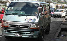
The Ministry of Urban Development is collaborating with the Ministry of Transport and Works on the redesign of the Kingstown Bus Terminal.
Minister

Hon Nigel Stephenson
Departments
Resources
Contact Information
Mrs. Laverne Grant
Permanent Secretary
Telephone: (784) 457-2031
PBX: (784) 456-1111 Ext. 3946
Fax No: (784) 457-1289
Email: ps.mtw@gov.vc

©
2026
Government of Saint Vincent and the Grenadines
Website developed and managed by the Information Technology Services Division
Website developed and managed by the Information Technology Services Division